Hey hikers and welcome to my post where we will check out my three best GPS systems for hiking to get you from A to B this year. When it comes to hiking, proper navigation is essential whether you are in the backcountry or on open water.
And as you are on the move, a handheld GPS navigator is perfect for allowing you to plan, follow and share recent adventures. And as usual, there is a wide range of options available today so to help you out I have had a good look around and come up with three decent choices below.
Let’s check them out…
My three recommended GPS systems for hiking
I will review these in more detail below, but if you just want to get moving without all the carry-on, my recommended products are listed here for your convenience:
What are GPS systems for hiking?
Handheld GPS devices combine modern geographic technology with a portable, user-friendly instrument for everyday use. Depending on the option chosen, they can incorporate many functions including navigation assistance, route finding, track recording or keeping trip records.
Certain models may also include features that provide information about geographical locations, such as national and historical landmarks and outdoor enthusiasts can also use the device to pinpoint the coordinates of a specific area for future reference.

What Should You Be Looking For?
The following factors should be considered as you look for a good portable GPS system for your hiking adventures.
- Power source
- Buttons or touchscreen
- Satellite messaging and SOS
- Mapping and memory
- Additions
Power source
The AA battery has long been the industry standard for GPS devices as are inexpensive, have long lifespans and can be replaced when they become drained. On the downside, bringing many of them is required if you are going on a long trip.
And whilst batteries are still an option for many GPS devices, forward-thinking manufacturers have turned to rechargeable battery packs as a compelling alternative – much like a smart phone.
Touchscreens, like smartphones, are becoming more common in the handheld GPS market. These devices are simple to use, easy to navigate, and can be used in landscape and portrait modes.
However, some of the best-rated models are equipped with buttons because the touchscreen technology and built-in software are not as advanced as our expensive smartphones, nor are they as consistent in harsh and cold weather. Using a touchscreen with gloves can be difficult, despite technologies that make some gloves work reasonably well.
Satellite messaging and SOS
Another factor to consider is the capability of the device to send and receive messages. This technology, which requires a subscription (often billed monthly with a one-time set-up fee), allows you to connect in areas without cell service, including sending and receiving texts, posting to social media, sharing your location, and communicating between GPS devices.
Some of the benefits for this functionality are obtaining weather reports, scheduling flights, and, of course, sending messages when accidents occur.

Mapping and memory
This feature is present in all handheld devices in the form of a basemap (basically a blank screen with some significant local features). Many include additional preloaded maps or the ability to upload more later on.
Most modern models include the cutting-edge TopoActive mapping, a reasonably comprehensive program with contour lines to indicate elevation gained/lost, points of interest and some on- and off-road navigation based on your country of origin.
Additions
Other potential additions include:
- Barometer: This feature gives you the barometric status of the area where you are in. Obtaining a reading on barometric pressure helps determine elevation because the pressure decreases as you ascend.
- Compass: As we all know, compasses help us find the right direction in case you lose your way during your hike.
- Waypoints: A waypoint is a reference point that can be used for navigation and location. This allows you to find the most direct route to your destination.
FAQ
Is it worth getting a handheld GPS?
Unless your hiking exploits make it difficult to carry one, a handheld GPS is well worth the investment in terms durability and functionality. They have larger screens with the ability to display greater detail as well as the ability to upload maps and pinpoint locations as well.
Can a GPS be tracked?
Short answer – No. GPS systems are designed to retrieve information rather than transmit meaning they do not give out locations. Some however do come with SIM card capabilities for added messaging and communication capabilities which does make them trackable much the same as a mobile phone.
My three recommendations broken down
So based on the information above and my own experience, I recommend the following options:
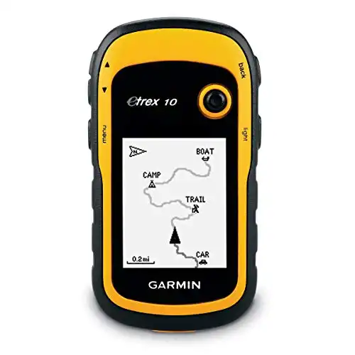
My first GPS option for hiking is a top pick for an entry-level unit for geocaching enthusiasts. The speed and accuracy of this baseline unit are impressive, making it a dependable option for tracking and waypoint marking. It is a good size with great durability and long battery life making it an excellent choice for use in inclement weather. See its specifications below:
- Brand: Garmin
- Screen size: 2.2 inches
- Display type: LCD
- Battery life: 25 hours
- Dimensions: 2.13 x 1.3 x 4.06 inches
- Weight: 0.619 pounds
- Power: AA batteries – 20 hours
Other inclusions:
- Preloaded basemap
- Waterproof
- Calendar and alarm clock
Why have I chosen it?
Because this is a simple GPS unit, it is effortless to use allowing you to quickly navigate the device’s single-screen menu and determine its main capabilities. The unit comes with four pre-set profiles to help you better manage options and settings and with a running time of 25 hours, this entry-level GPS tracking device can assist you for a long time.
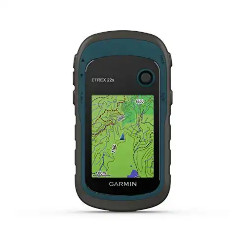
This second hiking GPS option comes at a great price whilst giving your reliable functionality as you explore the wild. It supports GPS and GLONASS satellite systems and allows for the quick transfer of map and route files from the GPS to the phones in your group. See its specifications below:
- Brand: Garmin
- Screen size: 2.2 inches
- Display type: Color TFT
- Battery life: 25 hours
- Dimensions: 4 x 2.1 x 1.3 inches
- Weight: 0.312 pounds
- Power: AA batteries – 25 hours
Other inclusions:
- 8GB memory
- Sunlight-readable display
- Compass
Why have I chosen it?
This hiking GPS is a durable and accurate navigation device, ideal for those who want to navigate and view topographic maps in the backcountry without relying on a smartphone app. It even has two storage options along with 8GB of internal memory and microSD card for downloading and transferring maps. It also includes City Navigator NT maps for turn-by-turn driving directions once you get back in the car as well.
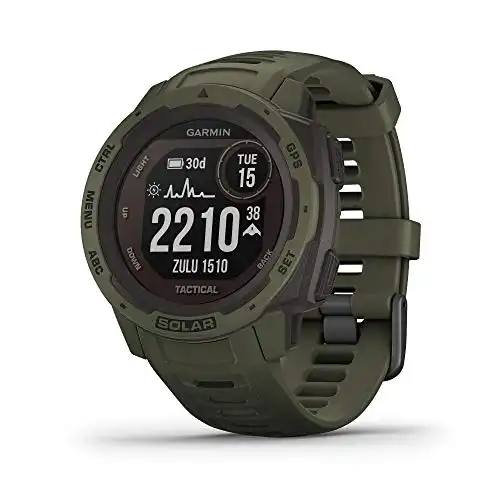
3. Garmin Instinct Solar Tactical Rugged Outdoor Smartwatch
The last GPS gadget for your hiking trips is a GPS watch with rugged design and impressive functionality. Aside from running, cycling, hiking, kayaking, yoga, and other everyday activities, the device also supports fishing, tactical, boating, hunting, area calculation and other outdoor-oriented trips too. See its specifications below:
- Brand: Garmin
- Screen size: 1.27 inches
- Display type: Not indicated
- Battery life: Up to 24 days; up to 54 days with solar
- Dimensions: 4.53 x 4.53 x 2.6 inches
- Weight: 0.37 pounds
- Power: Rechargeable solar battery
Other inclusions:
- Solar charging capabilities
- Built-in 3-axis compass and barometric altimeter
- All-day health monitoring
- Shock and water-resistant
Why have I chosen it?
The watch’s 100-meter water resistance and impressive shock ratings ensure it’s ready for anything. It was designed with a fiber-reinforced polymer case and a scratch-resistant display for guaranteed durability.
The device includes ABC sensors such as an altimeter for elevation data, a barometer for weather data, and a three-axis electronic compass. Furthermore, this hiking GPS gear gives you access to multiple satellite systems, making pinpointing your location and the best route quick and easy. This is a great option for hikers who want all the info without having to carry anything.


Conclusion
There you have it; my three best GPS systems for hiking that will help you navigate any hiking route you decide to take. I would be pleased to know how this article helped you, and as usual, let me know of your experiences with them.
Also, please do not hesitate to comment below if you have any questions, concerns, corrections, or would like me to check anything else out for you.
Until next time.
Have fun
Paul
